Visitors to this page

Saturday, 1 September 2012

Activities and responses in glacial environments


Now that I have covered all the basic information concerning glaciers that is needed for background knowledge, I am now going to move on to look at the interaction of people with glaciers and this particular environment. This is beginning to move slightly away from the more physical geography aspect and looking more at the human aspect of the subject (a much more welcome topic for me!). It is important to look at the human interaction in this environment as glaciers can provide both negative and positive aspects for people.


Tourism
Due to the erosional processes that occur as a glacier moves down the valley, the landscape it leaves behind is highly attractive for many walkers, hikers, mountaineers, photographers, skiers and many other people. This is a positive aspect for the surrounding communities as it generates money and contributes to the local economy.
However, although it may generate a lot of money there is also the negative side to tourism. If many people visit the area, walking and hiking it can have a negative effect on the physical environment and can cause damage to the vegetation and thus have a knock on effect on the wild life. As well as this, tourism is not always welcome by everybody and is seen in a negative light with local people when issues such as pollution and litter begin to arise.


Farming
One of the positive aspects of glacial environments is the deposits left behind. Glacial till in lowland glacial environments provides fertile soil for both arable and pastoral farming. This is a very positive aspect as it generates income for the local area as well as providing jobs for people. Glacial environments also provide farming opportunities in the upland areas – more specifically pastoral farming. This also helps the local economy. Not only this but it pastoral farming has been a way of life for centuries and is therefore now embedded in local culture.
However, there are some negative aspects of farming. Over-grazing in areas have a negative multiplier effect on many other variables; it can lead to soil erosion which then prevents vegetation from growing in the area and then means that there will be no where for wild life to live.


Water Supply
Freshwater is one of the most important resource that glaciers provide for people. Many rivers around the world are fed by melting ice water of glaciers, for example the Ganges River is fed by a glacier in the Himalaya mountains and therefore supplies many people with fresh water. Not only is it a key source of water for people in Bangladesh in India, but it also provides Hydro-Electric Power (HEP). Another example of the reliance of people on glaciers for water is in La Paz, Bolivia. Here, people rely on glacial melting from an ice cap to provide them with water during the many dry spells.
However, despite this huge positive aspect, there are many negative aspects implicated with HEP. To begin with, the creation of the necessary dams and reservoirs involves flooding large areas of land, of which sometimes contains numerous villages. This then creates many disputes and can lead people to having to completely relocate and change their way of life. As well as this, they also create an eyesore in the landscape and many people feel that they create visual pollution in an otherwise unchanged, scenic landscape.


Forestry
Highland areas in the UK are a good source of conifer forests. This therefore provides a lot of jobs for people in the area and also benefits the local economy. Not only this, but the forests also help to counter the effects of soil erosion that may occur as a result of tourism or farming (over-grazing).
Like the other activities, there are negative aspects of forestry. Forestry may contribute to a very uniform forest, not allowing other types of tree to be present and thus create a low diversity. This may impact negatively on wildlife species that may rely on a diverse forest for food and homes.


Settlements
Lowland glacial environments provide a good place for settlements as they are low and flat and are much more suitable than the highland areas which are more isolated with much harsher living conditions. The lowland glacial areas are also good for settlements as it much better for infrastructure and so, together with farming, make it easier for goods to be transported.
All the negative aspects of settlements are associated with this; pollution, high water and power consumption and the displacement of vegetation and wild life.


It is important, within this area, to highlight the fact that each of these scenarios have both positive and negative sides. When teaching this, it may be good to discuss with pupils and get them to think of ideas that may be positive and negative. After discussing, it would be good to then get them to create a table illustrating the positives and negatives associated with each activity. After this, using case studies to show these examples would be good to put what they have learnt into practise and to be able to actually see these conflicts occurring in a real life situation.


Links used:
http://www.geographypages.co.uk/glachuman.htm - Human use of glaciated areas

Friday, 31 August 2012

Glacial Landforms


Following on from the previous post on glacial processes, the next thing to look at are the glacial landforms that occur as a result of these processes. Due to the forceful action of erosion and weathering, the landscape through which the glacier moves is left looking very different to many other landscapes created from erosional and weathering processes.
There are two different types of landform that are created from glaciers: erosional and depositional

First of all I will start by looking at erosional landforms.

Corries (also known as cwms or cirques) are found at the top of the mountain where the glacier first begins. They are bowl-shaped hollows which form as a result of plucking, abrasion and freeze-thaw action as the glacier moves further down the mountain or valley. If the ice within a corrie melts, a lake often forms and this is known as a tarn.

U-shaped valleys form as a result of a glacier moving down the valley. Glaciers usually follow the path of old river beds and so the glacier continues to erode the v-shaped river valley, cutting through harder rock that the river could not erode and thus creates a much wider U-shaped valley. Characteristically they have a flat floor with steep sides. Glaciers are also much like rivers in that when they erode through the upper course of the glacier, they leave behind truncated spurs (on a river they are known as interlocking spurs).

Arêtes are sharp, knife edge, ridges of rock which form when two corries form back to back. Each glacier continues to erode either side of the strip between the two corries which eventually leads to the creation of a very steep and narrow ridge.

Pyramidal peaks form as a result of the meeting of 3 or more corries and arêtes. The continued erosion eventually leads to the formation of a pyramidal peak (also known as a horn).


Diagram illustrating the above erosional land forms

Ribbon lakes form as a result of the erosion by the glacier on the valley floor. As it flows 
over this land, softer rock erodes much quicker and easier as opposed to hard rock and so the glacier creates deeper troughs in the soft rock. When the glacier has retreated, water will begin to collect in these deep troughs and can create long, thin, ribbon lakes.

Crag and tail also forms as a result of the differential erosion of the soft and hard rock over which a glacier flows. As the glacier flows over soft rock it eventually hits an area of hard rock and so instead of cutting right through it, it goes over the hard rock. This area of hard rock protects the softer rock behind it, creating a crag and tail. One good example of a crag and tail is Edinburgh castle.

 Diagram illustrating a crag and tail (BBC Bitesize)


Now that I have finished looking at the erosional landforms created by glaciers, I am going to move on to looking at the depositional landforms.

Till, also known as boulder clay, is the debris that is deposited when a glacier has retreated and is made up of a variety of material, including rock, sand, gravel and mud.

Moraines are deposits that have previously been carried by a glacier and dropped as the glacier retreats. There are four different types of moraine:
            Terminal – found at the furthest point that was reached by the glacier
            Lateral – found along the sides of the glacier
            Medial – found at the place where two glaciers have joined together to    create    one, larger, glacier
            Ground – variety of sizes and types of rock found at the bottom of the glacier

Not all material that was once carried by the glacier is deposited as a moraine. Material is sometimes carried by the melt water streams and is deposited as it flows. As a result, after many years of this small, steep mounds of debris accumulates adjacent to the glacier, known as kames.

Erratics are large, unsorted boulders that are deposited once a glacier has retreated. As they are so large they are often found individually, and not in piles and are often of a different rock to that of the surrounding area.

Drumlins are large, long hills which are created as a result of glacial deposits. Although there is much disagreement on how precisely they were formed, it is thought that they were created when subglacial material that had accumulated from various erosive and weathering processes was deposited. As the drumlins are shaped by glacial movement, all of those created by the same glacier face in the same direction; running parallel to the flow of the glacier.

Diagram above illustrates the above depositional landforms


As has been the case with other areas that I have already covered within this glacial topic, I think it is important to incorporate imagery into the teaching. Visual aids help to show pupils what they are learning and it could be easier for them to remember the different terms if they have been able to see it. Another way to help the learning of these terms would be to hand out a diagram of a glacier valley and ask students to add the labels for the different landforms created.
BBC Bitesize as well as National Geographic have been very useful with this area and are filled with useful pictures, diagrams and resources which could prove to be very useful!


Links used:

Thursday, 30 August 2012

Glacial Processes

This blog post is going to look at a variety of glacial processes; erosion, transportation, deposition and weathering.


Looking first at erosion, there are two main processes that occur here: plucking and abrasion.

Plucking occurs when ice at the bottom of the glacier melts slightly as it moves. Often, the ice melts around large boulders and then refreezes around them. As the glacier then continues to move, these boulders are ripped up off of the ground and move along with the glacier and contribute to the process of abrasion. This process of plucking leaves behind a very jagged landscape.

Abrasion occurs when rocks become embedded in the base and sides of the glacier itself. As the glacier moves, these rocks rub and scour the bedrock and rock faces, acting much like sand paper. This results in the rock surfaces becoming highly polished with large grooves in them, known as striations.

The above diagram gives a brief illustration of the processes of plucking and abrasion as well as where about on the glacier they would occur (http://www.bbc.co.uk/schools/gcsebitesize/geography/glacial_landscapes/glacial_erosion_landforms_rev1.shtml)


Secondly, we will be looking at weathering, in particular freeze-thaw.

Freeze-thaw weathering occurs when water enters joints and cracks in rocks and then freezes as the temperature drops. As water freezes, it expands and exerts pressure within these cracks and causes them to widen. As temperatures begin to rise again during the day, the water thaws and contracts. This recurring process causes the rock to weaken and eventually they break up. These rock pieces may then contribute to the process of abrasion.


The next section will be transportation.

Material carried within a glacier is known as moraine. Moraine can be transported on the surface of the glacier, known as supraglacial moraine, or internally (englacially). Debris collected from valley sides as the glacier moves is known as lateral moraine. If two valley glaciers meet and then merge together, the lateral moraine of the two glaciers also merges together and forms what is known as medial moraine and runs down the middle of the newly formed glacier.

The image above illustrates the different type of moraine that is transported within a glacier.


Lastly, we will be looking at deposition.

As temperatures begin to fall, the ice within a glacier begins to melt. This therefore means that the glacier cannot carry as much material and so it deposits it. The rocks and boulders that the glacier puts down is known as till or boulder clay and is an assortment of different sized and shaped material (unsorted). The main depositional feature of a glacier is the terminal moraine - material deposited at the very end of the glacier. However, it will also eventually deposit the lateral and medial moraines alongside the ground moraine (debris found at the base of the glacier).

Looking for information on this part of the topic led me to many revision and text book websites which has led me to see that this information is not only readily accessible but also very easy to use and explain. There have been a number of useful diagrams and explanations and some websites have even provided short videos to help show the written explanation. These will all be very useful when teaching as it is sometimes difficult to understand things purely from a written or spoken explanation. Often, within this topic, it is easier to show diagrams and videos as it gives a better idea of what is happening and helps to apply what has been learnt to a real life scenarios.

List of websites used:
http://www.bbc.co.uk/schools/gcsebitesize/geography/glacial_landscapes/glacial_deposition_landforms_rev1.shtml - BBC Bitesize
http://revisionworld.co.uk/a2-level-level-revision/geography/glacial-environments/glacial-processes-landforms/erosion-processes - erosion processes
http://www.pearsonhighered.com/christopherson8einfo/downloads/Christopherson_Chapter_17.pdf - Geosystems, Christopherson
http://www.s-cool.co.uk/gcse/geography/glaciers/revise-it/glacial-processes - S-cool revision
http://education.nationalgeographic.com/education/encyclopedia/glacier/?ar_a=1#page=2 - National Geographic


Wednesday, 29 August 2012

Types of Glacier

Firstly, I would like to apologise for the long break between my last blog post and this blog post (I have spent the past month in Chile - a geographers paradise!). However, blogging shall continue as normal from now on, resuming with types of glacier.

It is important to note that glaciers are classified based on two factors: size and topography. Due to this, they are broadly classified into two groups: alpine glaciers and ice sheets. Firstly, we will look at alpine glaciers.

Alpine glaciers classifies those which are formed on mountains and can be found in the world's highest mountains and are found on most continents (although there are none in Australia, alpine glaciers can be found in New Zealand). Due to this, they are often known as mountain glaciers.

Mountain glacier found in the Andes. (http://www.unep.or.jp/ietc/publications/short_series/lakereservoirs-2/4.asp)

Valley glaciers are those which have commonly originated from mountain glaciers. They begin to move down into valleys and can be very long, some often exceeding the snow line and may even reach sea level.

Mer de Glace Valley Glacier, France (http://www.aber.ac.uk/en/iges/research-groups/centre-glaciology/research-intro/valley-glaciers/)

Hanging Glaciers are so called due to the fact that they cling to the side of steep mountains. They usually form at the top of a mountain or valley but doesn't descend into the main glacier or valley below. Instead, the ice often calves in avalanches to the glacier or valley below (making them often extremely hazardous).

Mt.Kefton, Antarctica Hanging Glacier (http://nsidc.org/cryosphere/glaciers/gallery/hanging.html)


Piedmont glaciers are found when valley glaciers flow from a relatively narrow valley into a much wider valley or plain. Due to this, they then spread out into large, bulb like features. The largest Piedmont glacier in the world is found in Alaska: the Malaspina glacier. It spreads over 5,000 square kilometres and can be seen in the picture below:

(http://nsidc.org/cryosphere/glaciers/questions/types.html)

Cirque glaciers are named after the bowl shaped hollows that they occupy which are known as cirques. They are most usually found high up on the side of mountains and are most often wider than they are long.

Teton cirque glacier, Wyoming, USA (http://www.swisseduc.ch/glaciers/glossary/cirque-glacier-en.html)

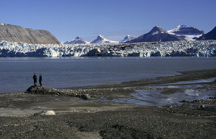
Tidewater glaciers are valley glaciers which have flown far enough that they reach the sea. The leading edge of the glacier lifts up and floats in the water which thus forms cliffs of ice. Huge chunks of ice may break off at the edge of the glacier, a process known as calving.
Kronebreen tidewater glacier, Svalbard (http://www.swisseduc.ch/glaciers/glossary/tidewater-glacier-en.html)

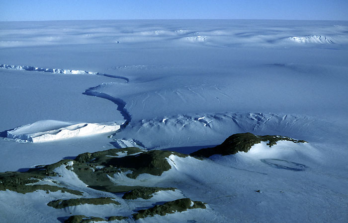
The last type of glacier that we will look at will be ice sheets. These can only be found in Antarctica and Greenland and are not restricted to mountainous areas; instead they spread out in all directions from the center and cover vast areas. The largest of ice sheets are known as continental glaciers.

The edge of the East Antarctic Ice Sheet (http://www.swisseduc.ch/glaciers/glossary/ice-sheet-en.html)

This blog post has looked at the different type of glaciers that can be found and has identified each type with a photograph. When teaching this section, I think it would be important to illustrate each glacier with a picture as it is often easier to remember and learn about them with a visual aid. It is a brief section which could be taught in the form of a simple game, matching pictures and definitions, as was done for the key vocabulary table in a previous blog post. This would help to make the lesson a bit more fun for students and would help to further engage them with the topic.

I just want to round this blog post off with a good video I found on the BBC website showing a glacier in action (definitely helped by the fact that Sir David Attenborough is the narrator!): Glaciation In Action - Frozen Planet

Links used:
http://nsidc.org/cryosphere/glaciers/questions/types.html - National Snow and Ice Data Centre
http://iceland.vefur.is/iceland_nature/glaciers_in_iceland/ - Icelandic Glaciers
http://education.nationalgeographic.com/education/encyclopedia/glacier/?ar_a=1 - National Geographic
http://www.swisseduc.ch/glaciers/glossary/ice-sheet-en.html - Glaciers Online
http://www.unep.or.jp/ietc/publications/short_series/lakereservoirs-2/4.asp - UNEP

Friday, 20 July 2012

In the news

Having decided upon glaciers as my topic of choice for this blog I have been keeping my eyes open for any relevant news articles or recent developments in the field. Luckily enough, I have found two such things!
Firstly would have to be the news that came through on the 19th of July about the Petermann Glacier in Greenland; an iceberg estimated to be the size of Manhattan broke away from the tongue of the glacier - a process known as calving. What makes this event so momentous is the fact that in 2010, another substantially big iceberg broke away from this same glacier. Scientists are worried by what has happened due to the size of the iceberg as well as its history. This news article shows how relevant this subject is and how  it is constantly being updated with more information and developments being made frequently as more research is carried out.
At the bottom of the news article I found a very interesting interactive tool in which you put in your postcode and you can see how big the newly formed iceberg is in relation to where you live. From a teaching perspective this could engage the children with the subject; being able to see how big the iceberg is in relation to where they live could interest them and could help to show them the actual scale of what they are studying.
If you are interested, here is the link to the article (the interactive map is at the bottom!): 'Iceberg breaks off from Greenland's Petermann Glacier'

The second update I have found was actually through my University - Aberystwyth. Dr. Bethan Davies a research associate has just set up a new website entitled 'Antarctic Glaciers'. It is a brilliant new website with lots of information on glaciers which is easily accessible and easy to read. As Dr.Davies continues to do research, the website is updated on new information that is found out and lots of interesting things discovered during her research period. Not only this but there is also an 'Ask a Scientist' section in which, if you have any questions you can ask them and get them directly answered by somebody in the know! I think it could make a valuable resource as it is easy to use and provides a lot of answers!
If you would like to look at the website you can do so here: http://www.antarcticglaciers.org/
They are also on twitter with their updates @Antarcticglacie


Enjoy!

Wednesday, 4 July 2012

Definition Galore

After my last post, I was left feeling slightly encouraged by the start I had made; sure, it hadn't been extensive on the knowledge front but it was a start. However, as I started to move on, looking at how glaciers form and the types of glacier I began to feel that I was missing something. As I continued to look through websites and diagrams I realised abruptly what it was that I felt I needed in this study; key terms. I therefore set about creating a table filled with terms that I felt would be important to contribute to my knowledge:


Key Term
Definition

Ablation
The process by which ice is lost from a glacial surface through the processes of melting, sublimation or the calving of icebergs
Areal Scouring
The erosion of lowland bedrock areas by an ice sheet (usually large scale)
 Arête
A sharp ridge of rock formed as a result of glacial erosion occurring from both sides

Basal Ice Layer
The layer of ice that is found at the base of a glacier. It is strongly layered and can include a variable amount of debris

Basal Sliding
The movement (sliding) of a glacier over bedrock. This is often aided by the effect of meltwater

Bergschrund
A crevasse which forms as a result of active glacier ice moving away from ice adhering to the mountainside

Boulder Clay
Unstratified clay deposited by a glacier and consisting of a variety of boulders. Often referred to as 'till'

Cirque
An armchair shaped hollow which has formed as a result of glacial erosion high on a mountain side with steep sides and back wall. Also known as a 'corrie' or a 'cwm'


Crag-and-Tail
A glacially eroded rocky hill. Produced as ice moved over a hard layer of rock which protected softer rock behind it. This formed an outcrop with a steep side facing ice flow and a gentle slope on the down stream side


Crevasse
Vertical crack in the glacial ice. May be formed as a result of the glacier making a sharp turn or moving over undulations in the glacier bed. Can vary in size and depth


Drumlin
Elongated, oval hill composed of glacial debris. The long axis runs parallel to the flow of the original glacier with the steeper end facing in the direction of the ice flow.
Englacial Conduit
A channel formed within the glacier which carries waters towards the glacier bed or margins

Erratic
Boulders, or large blocks of bedrock that has been, or is being, transported away from its source by a glacier and deposited when the ice melts

Esker
A long, narrow ride of sand and gravel deposited by a stream in a subglacial tunnel

Firn
Dense old snow (in between the stages of snow and glacial ice) that has a sugary texture and in which the crystals are partly joined together

Hanging Valley
A tributary valley with the floor at a higher relief than the main channel into which it flows. Often marked by a waterfall
Ice Sheet
A large mass of snow and ice of a considerable thickness and covers an area of more than 50,000km²


Little Ice Age
Period of time which led to the expansion of valley and cirque glaciers world wide. Maximum extent occurring in 1700-1850 AD in many temperate regions
Moraine
Distinct ridges and mounds of debris laid down by a glacier or pushed up by it. Many different types
Lateral Moraine
Debris deposited along the side of a glacier
Medial Moraine
Band of debris along the centre of a glacier where two streams of ice merge

Terminal Moraine
Ridge running across a valley which represents the maximum advance of a glacier

Ground Moraine
Debris deposited on valley floor. Found where glacial ice meets rock at the bottom of the glacier

Push Moraine
Assortment of debris that has been pushed up by a glacier during an advance. Can range from a few metres to tens of metres in height.

Moulin
Roughly circular, almost vertical hole within the glacier through which water can enter from the surface down the glacier bed
Outwash plain
Spread of debris deposited by meltwater streams coming from a glacier


Roche Moutonée

Rocky hillock with a gently inclined, smooth up-valley facing slope and a steep, rough down-valley facing slope

Striations
Scratch marks found on rocks as a result of the abrasive effect of debris rich ice sliding over bedrock
Tarn
Small lake occupying a hollow eroded by ice; common in cirques

Truncated Spur
River spur that has been cut off by glaciation of a former river valley. Characterised by a very steep cliff


A  lot of these words are quite long and complicated, especially words taken from the French and German language such as Bergschrund and Rouche Moutonee and so it may take a while for students (as well as myself) to fully get to grips with these terms. Showing students pictures alongside these definitions may also help with the learning of these terms as it is sometimes easier for students to be able to see and apply their knowledge rather than purely being told. After composing this table, I feel that I have furthered my knowledge purely by just understanding the key terms that I keep coming across. As well as this, I also felt that I may have even be halfway to composing a potential lesson resource! Handing out this table, or one somewhat similar, in lesson and getting students to either stick it in their book for reference or for an activity in which students would be handed the definitions and key terms separately and then asked to put the correct term and definition together. This could help to see how student have progressed with the topic as well as helping them further their own knowledge on the subject.


Finally, I also looked at how glaciers are formed. After trawling through many websites, images and youtube videos, I found that many of the diagrams were slightly misleading and confusing and so I went back to the National Snow and Ice Data Centre website which I felt gave the most succinct information that I needed. Essentially, glaciers form when snow remains in the same area every year and accumulates to the point where it eventually transforms into ice. As this process continues, the new snow that has accumulated buries and compresses the previous layers. This results in the snow re-crystallizing and becoming similar to grains of sugar. Over time, these grans become much larger in size and the air pockets between the grains becomes smaller causing an increase in density and eventually, over roughly two winters the snow turns into firn (refer to table above for definition). As the process of accumulation and compression occurs over many years, grain sizes become larger and larger and thus, a glacier is formed.

This, I feel, begins to explain not only how a glacier is formed but a few key terms which could be helpful for students to see how all these key terms fit together within the topic.


Overall, the creation of a key term table at the beginning of the topic could be helpful for pupils to refer back to throughout the learning of the subject as a helpful referencing guide as well as an aid for learning and revision. Creating activities around the table could also help to make lessons more interesting and engaging, assisted with pictures for an aided aid. 
The next aim will be to look at the different types of glacier that can be found - something images will be very helpful for!

Websites used:
http://www.swisseduc.ch/glaciers/
http://nsidc.org/cryosphere/glaciers/questions/formed.html
http://www.geography-site.co.uk/pages/revision/ice.html

Monday, 18 June 2012

Glaciers from the very beginning

After completing my subject knowledge audit I was woefully aware of my lack of glacial and periglacial knowledge, having only ever encountered these two topics in my first year at university as part of one module (amounting to exactly 2 lectures worth of a quick overview). Since that point, the only time the glacier has been mentioned has been in relation to the Last Glacial Maximum after having covered this in quite a few modules relating to biogeography. Therefore, I am having to start right at the very beginning to try and get to grips with something I have been somewhat determined in avoiding. However, given that this is all in aid to help me help others, I think that it might be somewhat beneficial for me as it will set me back to a classroom sort of level and give me a further appreciation of how difficult or easy it is to learn something completely new from the very beginning.


I feel, after having gone through secondary and higher education level geography, the best place for me to start would be with a good, old fashioned definition. Looking at a variety of sites online, from Extreme Ice Survey to online physical geography dictionary's, the general consensus seems to be:


"Large masses of ice formed through the accumulation of snow over many years. They form in areas where snow fall in winter exceeds snow melt in summer."


This seems fairly basic and straight forward; easily memorable and begins to move in the right direction.


Next, I decided to look at basic facts and where you can find them in the world. Looking at the National Snow and Ice Data Centre (which has been my main calling point thanks to its large section on glaciers!) they have covered about 10% of the total land surface area; a fairly substantial amount and store an estimated 69% of the worlds freshwater. They are usually found in mountainous regions, given the altitude and weather patterns that occur in these areas. Looking at the USGS, I managed to find the following map which shows the areas of the world where glaciers can be found:


Looking at the different places in relation to their climate and altitude, it is unsurprising where they can be found; along most of the mountain ranges in the different continents. Maybe somewhat surprising is the location of glaciers in Africa! They are generally found above the snowline which is why they are generally found in mountainous regions but this differs in different parts of the world, hence why they can be found in Africa.


This general overall of glaciers is a good place to start in helping to identify what they are; both the definition and the map are key indicators which can help to try and start getting your head around the subject. Taking into account climatic conditions associated with them (for example precipitation and temperature) can help to show the type of formation they are and why they form - although this will be looked at it further detail.


Overall, this first post has helped me to get my foot in the door of the topic of glaciers by looking at the basics. Having a quick look over my university notes, I know I have yet some way to go but I feel that teaching students this topic, this would surely be the best way to start as it is simple yet easy to comprehend. Next time I think will become more challenging looking at how they form and the different types of glacier - an area with many names and technical terms to remember (unfortunately!). Trawling youtube for videos I think is going to be my first port of call!