
Now
that I have gone through the processes that occur in a periglacial environment,
I am now going to focus on the landforms that are created as a result of this.
Pingos – These are one of the common features of a
periglacial environment and are created as a result of frost heaving. Pingos are dome
shaped hills (with an ice-core) which can be between 3 meters and 7 meters in
height and can be up to 1,000 metres in diameter. Pingos fall into two categories: closed-system
and open-system.

Pingo
in the Arctic
Closed-system: These form in areas where
unfrozen groundwater becomes trapped by permafrost which puts pressure on the
surrounding soil pores and forces the water inwards. As temperatures drop, the
water freezes and expands, causing the frozen soil above to be forced upward,
creating these mounds.

Open-system: These are usually smaller than
closed-system Pingos. These form when groundwater flows downhill and becomes
trapped by permafrost. The water will eventually force itself in an upward
direction where it then freezes, resulting in the soil above it being pushed
into a cone-shaped mound.
Thermokarst – This is the name given to very irregular
surfaces of a mixture of hollows and hummocks. Small domes form on the surface
during the winter period as a result of frost-heave action. As the summer
approaches, the ice thaws which then causes these domes to collapse which
create small depressions on the surface. However, some ice lenses may grow and
create larger hummocks which may last for more than one year and may even
become covered with vegetation. Even though they may last for more than a year
they will eventually collapse during a summer thawing period. This process of
thawing and freezing creates this uneven surface.

Thermokarst
in Yakutsk
Patterned ground – This is the name given to distinct, and often
geometric shapes, which are formed by ground material. These are created by the
continuous process of freezing and thawing of groundwater which pushes stones
towards the surface as smaller soils flow and eventually settle under these
stones. Over time, this freezing and thawing process sorts out the material to
eventually create patterned ground.
There
are several types of patterned ground:
Circles: sorted sediments with finer material in the middle
and larger material on the outside creating a circle shape.
Circle
type patterned ground in Svalbard
Polygons: These form as water freezes and
expands, pushing apart the grains of soil in the active layer. This then creates small cracks. Water then
fills these cracks and the process of freezing and thawing occur which wedge
the crack open. As the freezing and thawing continues, the wedges become bigger
and so a polygon pattern is created.
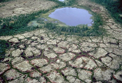
Polygonal
patterned ground
Steps: These generally develop from circle and
polygonal patterned ground. It is usually a terrace-like feature with a border
of vegetation or large stones and contains both sorted and unsorted material.
Stripes:
These are lines of stones, vegetation and soil and can consist of either
sorted or unsorted material.

Stone
stripe
Palsa – These are low mounds which contain permanently
frozen ice lenses. They are usually 1-7 meters in height and may be 15-50
meters in length. They are formed from groundwater and often occur in groups.

A
group of palsas from a birds eye view
As
with glacial landforms, I think it is important that pupils are able to have a
visual aid when learning these periglacial landforms. At the end of the lesson,
to help cement what has just been learnt, a sheet with glacial and periglacial
landform pictures could be handed out and pupils have to determine what the
landform is and whether it occurs in a glacial or a periglacial environment.
Links
used:
No comments:
Post a Comment